Long-time London resident and avid museum and theatre-goer. I started this blog in 2014, and got serious about it in 2020 when I realised how much I missed arts and culture during lockdowns. I go to a lot more events than anyone would think is sensible, and love sharing my thoughts in the forms of reviews, the occasional thought piece, and travel recommendations when I leave my London HQ.
Tracing London’s lost rivers is a great way to see new parts of London and connect with the city’s heritage. Particularly when most other cultural offerings are off limits! In this walk, I follow the path of the Neckinger river from the Oxo Tower to St Saviour’s Dock.
My handy guide to the path of the Neckinger – Tom Bolton’s London’s Lost Rivers: A Walker’s Guide
Heritage Walks to Fill the Gap During Lockdown
So, avid blog readers. We are in a position I didn’t foresee when I relaunched the Salterton Arts Review in July 2020. I am now rationing my final few pre-lockdown posts, and interspersing some good old heritage walks. Heritage walks are now about the only thing we can do physically to connect with culture and heritage. There is plenty of online content, of course, but I am very much a Benjaminian when it comes to authenticity. For me, nothing replaces being there in the flesh or seeing something with my own eyes.
This is why heritage walks are perfect for me. Luckily I had several books of London walks already, so am not likely to run out of ideas. I love discovering new neighbourhoods, random side streets and overlooked oddities. So until things are a little more back to normal, I will be sharing some of these outings with you.
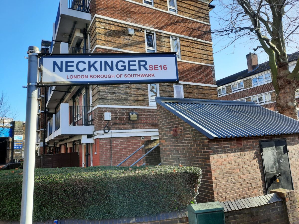
Today’s walk concerns the Neckinger River. The title is a little misleading as it is not London’s only lost river, it’s one of several. Some of them we still recall, like the Fleet, but others, like the Westbourne, Walbrook or Effra, I for one had not heard of before picking up Tom Bolton’s walker’s guide. The Neckinger is a peculiar not-quite river. There is no trace of it today at all apart from its outlet to the Thames, and the path I followed was a little semi-circle of former channels, streams and finally what used to be a discernable river. Along the way I learned about London’s industrial past, as well as spas and pleasure gardens, abbeys, famous citizens and other traces of daily life over many centuries of London living.
Join me now on this walk along one of London’s lost rivers.
Walking the Neckinger River– Southbank to Southwark
The walk starts at the Thames by the Oxo Tower. You can see traces of the Old Bargehouse Stairs on the foreshore. This is where a stream or drainage channel is shown on old maps emptying into the Thames, so forms one end of the Neckinger’s route.Some recent heritage at this end of the walk is the work of the Coin Street Community Builders. Active from the late 1970s, this community action group has been successful in preserving parts of the heritage and the residential nature of the Southbank. Without them, one of the best parts of London would likely have lost a lot of its character.So many place names in London give clues to their past. Hatfields is where milliners once dried the skins they used in their hat-making workshops. This whole area was once very marshy and boggy. In the 18th Century a man named William Curtis set up a botanic garden here of mostly aquatic plants. Curtis’s Botanical Magazine is still published today by the Royal Botanic Gardens at Kew.Arts and Crafts cottages on Ufford Street, a model housing development dating to 1902.This pub is currently The Stage Door, but was once the Half-The-Way Inn. Frequented by Samuel Pepys (where wasn’t?) in 1665.That tall building was once the headquarters of MI6, now flats. Apparently while working on the conversion, workmen found things like secret tunnels to the nearest underground station, and a chemical disintegrator for documents.
Not officially part of the walk, but just a little local heritage. A nice survival of an idiosyncratic barber’s shop with eclectic/nostalgic decoration.
Walking the Neckinger River – Lambeth to Elephant and Castle
Morley College is a long-standing centre of adult education. In its early days, before securing its own premises, founder Emma Cons arranged ‘penny lectures’ at the Old Vic. It moved to this site in the 1920s, and sustained heavy damage during the Blitz. Luckily it seems its currently boarded up for redevelopment work rather than to be turned into luxury flats or similar.
Across the street from the previous Morley College building are a series of mosaics featuring notable women with a local connection. Here we have Octavia Hill, co-founder of the National Trust, and Mary Seacole, prominent nurse and contemporary of Florence Nightingale.The Imperial War Museum. But before it was the IWM, it was St George’s Spa (waters later described as ‘decidedly unsafe’); a School for the Indigent Blind; and later Bethlem (Bedlam) Hospital.A Soviet WWII Memorial in the park next to the IWM. The park was once part of St George’s Fields, site of protest, riots and massacre.That water tower in the background, now quite a nice looking penthouse, was once part of Lambeth Workhouse. Charlie Chaplin and his mother spent time here in 1896. The photo is taken from Brook Drive, a reminder of the Neckinger which once flowed here.The Metropolitan Tabernacle at Elephant and Castle is rather imposing. It was built in 1861 for Charles Spurgeon, ‘The Boy Preacher’.
The changing face of London. The post-war shopping centre at Elephant and Castle, after a long struggle, was finally boarded up in 2020 ahead of redevelopment. The brutalist Heygate Estate next door, due for renovation at the time Bolton wrote his walking guide, has already gone.The boxy structure in the middle, which looks a bit like a power substation, is a monument to local boy made good Michael Faraday.
Walking the Neckinger River – New Kent Road to St Saviour’s Dock
The building on the left, Driscoll House, was originally a women’s hostel. Later owner Terence Driscoll filled it with religious imagery and rented it to foreign students. It’s currently a youth hostel.Once a jam factory employing around 2,000, this is now flats known as… The Jam Factory! There is a little garden open to the public.
This whole area was once the site of Bermondsey Abbey. It was once very important (several royal widows saw out their days here), but not much survived the Reformation. The monks once had a tidal water mill here to use the Neckinger’s waters, like that at House Mill on the River Lea.The former leather mill at Neckinger Mills was one of the last vestiges of the extensive tanning industry in this part of London. Tom Bolton writes that the stink once made it “impossible to enter Bermondsey unawares.”Just one of London’s many closed pubs and not part of the walking tour, but its unusual name caught my eye. This was once Lilliput Hall. Surely not the manliest of drinking establishment names for a fairly industrial area? The website I’ve linked says it was one of London’s first jazz pubs.In this part of London the Neckinger’s waters were once diverted into tidal ditches so it could drive a series of mills. This created ‘Jacob’s Island’, a notorious, filthy, miserable place once known as the Capital of Cholera. In Oliver Twist, Bill Sikes falls to his death from here into the polluted mud of the Neckinger. Very little of this dark history remains to be seen today, apart from the odd warehouse.We’ve made it! Medieval monks enlarged the Neckinger inlet into St Saviour’s Dock. I couldn’t see much of anything flowing into the Thames at low tide. This site, near the former Design Museum, was home to a gallows for many centuries, and has had barges moored here since the early 19th Century.


12 thoughts on “Walking the Neckinger – London’s Lost River”